


Case Study Information
Advanced photon-counting LIDAR for autonomous surface navigation
IS-Instruments, working alongside a consortium of project partners, developed an advanced imaging LIDAR system for future planetary landing applications as part of a programme supported by the European Space Agency.
The project focused on the development of a compact, high-speed photon-counting LIDAR system capable of supporting autonomous landing operations on the Martian and lunar surfaces.
Designed to operate across extreme measurement conditions, the system combined high-resolution ranging performance with rapid spatial data acquisition to support terrain mapping and navigation during landing operations.
The Challenge
Planetary landing systems must operate reliably across highly dynamic environments and rapidly changing target distances. During descent, the distance between the spacecraft and the planetary surface can vary from several kilometres to only a few metres within a short period of time.
To support autonomous navigation and hazard avoidance, the system required:
- Extremely large dynamic range
- High-speed distance measurement capability
- Accurate terrain mapping
- Compact, low-mass instrument architecture
- Low power consumption
- Reliable operation under demanding environmental conditions
The instrument also needed to generate dense spatial ranging data in real time while maintaining high measurement accuracy throughout the landing sequence.
The Solution
To address these challenges, IS-Instruments developed an imaging LIDAR platform based on a silicon photon-counting array detector combined with a high-speed scanning system.
The instrument used a unique 256-pixel Geiger-mode detector array to recover a full 20-degree field of view while supporting rapid acquisition of high-resolution ranging data.
The resulting system achieved:
- Operating distances ranging from a few metres to approximately 5 km
- Range resolution approaching 2 cm
- Approximately 2 million range measurements per second
- Dynamic range exceeding 10⁶
The compact instrument architecture was designed to operate with power consumption below 60 W and a total mass below 8 kg.
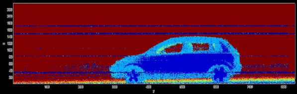
Ground Testing
The imaging LIDAR system underwent initial ground-based testing against a variety of target environments, demonstrating accurate ranging performance and high-speed spatial measurement capability.
These tests validated the system’s ability to generate detailed 3D ranging information across complex target scenes while operating at significant stand-off distances.
Key Features
- Photon-counting imaging LIDAR
- Operating range from metres to several kilometres
- Approximately 2 million range measurements per second
- Range resolution approaching 2 cm
- 20-degree field of view
- Compact low-mass system architecture
- Power consumption below 60 W
- High dynamic range performance (>10⁶)
Project Outcome
The project demonstrated the viability of high-speed photon-counting imaging LIDAR for future planetary landing applications.
By combining advanced detector technologies with compact optical system design, the work contributed to the development of next-generation autonomous sensing and navigation technologies for harsh and remote environments.